Page last updated 31/05/07
A Tour In Westmorland by Sir Clement Jones, published 1948
CHAPTER XI
THE SOUTHERN BOUNDARY OF WESTMORLAND
BURTON-IN-KENDAL - ARNSIDE - BEETHAM
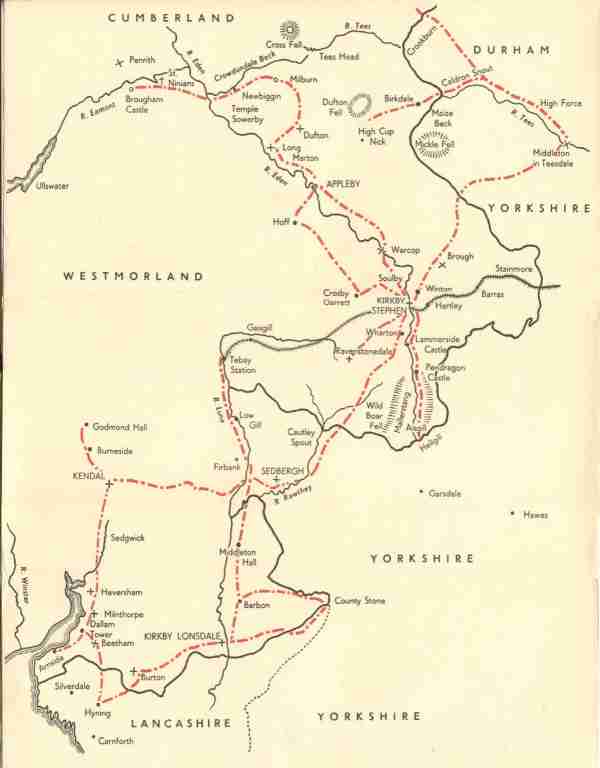
In this tour of the country near the boundary of Westmorland I
come finally to the southern part of the border, which is almost a straight
line, of about ten miles, running from west to east, from Arnside on the sea to
Kirkby Lonsdale on the Lune.
If I had to do this tour all over again - and I should like
nothing better - I should make one or two slight changes in the route, and next
time I should make Milnthorpe1 my headquarters for an intensive study of the
southern border. With a car you could do the whole thing in two days. As it was
we did it in instalments, the first bit being done by car from Kirkby Lonsdale
to Hyning near Warton in Lancashire, where we spent two delightful days.
From the high ground above Hyning you can get a good look at
the sort of country that there is along the southern part of Westmorland. It is
totally different from what we had seen of the boundary in the Pennines, or
along the Tees, or over Stainmore, or down Mallerstang way, or in the Lune
Valley. In all those parts of the border you are close up to the fells. But
here, from Arnside to Kirkby Lonsdale the lie of the land is relatively flat and
open and looks far more fertile. There are mountains in the picture such as
Ingleborough but they are in the distance, in the background.
The only exception is Farleton Knot, near Burton, which stands
conspicuous and alone and is described by West in his "Guide" as "a beautiful,
naked, limestone mountain, said to resemble much in form the Rock of Gibraltar."
We took two good walks from Hyning. The first was to Burton by
way of Tewitfield, crossing the boundary between Priest Hutton (in Lancashire)
and Dalton (in Westmorland). Dalton was formerly in the county of Lancaster, but
was added to Westmorland in 1896. This rearrangement makes the slight southern
bulge in the county line. It was 12th June and grand weather for haymaking, but
the date was full early for mowing and, therefore, knowing the average farmer's
prejudice in favour of "bulk" and late "cutting," I was surprised, but pleased,
to see two carts hard at work "leading" hay not far from the border. Another
mile, passing Dalton Hall, brought me into Burton.
Burton-in-Kendal, to give it its full name and distinguish it
from Burton-in-Lonsdale, is a pleasant village, situated in a valley on the old
northern road, 11 miles south of Kendal, 11 miles north of Lancaster. The fact
that it was a stopping-place for coaches, more than a hundred years ago, is
sometimes still remembered by those who heard about it from their grandparents
and mention is still occasionally made of the clatter of hoofs and the sound of
the horn in the Market Place, in the days when roads really were roads, before
they had become mere racing tracks for road-hogs. In those days Burton was a
much busier place than it is now; the market was established in 1661, and in the
course of the next century had become the most extensive corn-market in that
part of the country; most of the corn was brought here by the farmers of North
Lancashire, from whom it was bought by dealers from Kendal, Sedbergh and Kirkby
Lonsdale.
Burton is well-placed for transport facilities, for in
addition to the motor-bus service on the old road, there is a station on the
main line of the L.M.S. about half a mile from the village, and the Kendal and
Lancaster Canal also passes through
the parish, with whatever contribution that may make to the goods traffic. Yet
in spite of all these means of getting to and fro, I found the Market Place delightfully peaceful on a
sunny June afternoon with very few people stirring. Many solid, well-built
houses surround the market-cross, bearing witness to past and no doubt present
prosperity, for the whole place has a clean, well-kept appearance. I was glad to
see a notice posted up by the Women's Institute that there was to be a parkin
biscuit competition. I trust that the making of this delectable mixture of
oatmeal and treacle may never be forgotten by the housewives of Burton or become
a lost art in Westmorland.
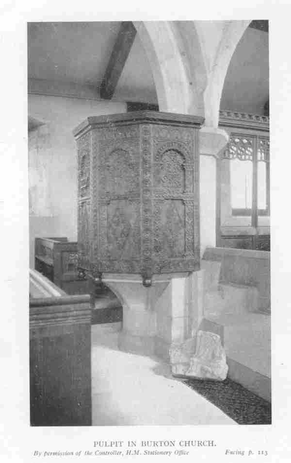
The Parish Church of St. James is an ancient building at the
north end of the village. The earliest part is the 12th century west tower; a
north aisle was perhaps added in the 13th century; the south arcade was built
and the south aisle added in the 14th century. There are some fine examples of
carved, old oak in the pulpit and chairs. The parish of Burton contains a large
number of old and interesting houses, of which a list is given in the
"Historical Monuments Survey," and though I looked at several of them I had not
time to see them all as I had to catch the bus back to Warton.
Our other walk from Hyning was to Leighton Moss in the
direction of Silverdale and the coast. This took us over the northern shoulder
of Warton Crag. On the top of the high ground above Yealand Conyers there is a
gazebo with a remarkable view in every direction. It is another "scream point."
Though it is in Lancashire it can fairly be mentioned in this book, because
looking to the north and east you cn see, spread before you, the southern
boundary of Westmorland. From the top of this hill, facing west, you look across
the sands of Morecambe Bay to Humphrey Head; "about turn" and you see
Ingleborough due east, for Humphrey Head, Yealand Conyers and Ingleborough are,
as near as makes no matter, on the same line of latitude, 54 degrees. To the
south lies Lancaster. Dropping down the hill on the wet side, by a public
footpath, we came close to Leighton Hall and beyond it to Leighton Moss.
Celia Fiennes came this way on "her great journey" in 1698
when she travelled on horseback from Lancaster to Kendal by way of Leighton Hall. She notes the "steepe stony
hills," over which she rode, the shade of the tall tress at Leighton; "thence to
Kendall ten mile more most of the way was in lanes when I was out of the stony
hills, and then into inclosed lands; here in six-mile to the town you have very
rich, good land enclosed, little round green hills flourishing with corn and
grass as green and fresh being in the prime season in July; there is not much
woods but only the hedge rows round the grounds which looks very fine; in these
northern countyes they have noe wheate or rhye, for they are so cold and late in
their yeare they cannot venture at that sort of tillage."2
Leighton Moss itself is a low-lying, swampy bit of ground and
a sheet of water; here we saw masses of yellow iris and birds innumerable -
heron, reed-bunting, sedge-warbler, swifts, black-headed gulls, dabchick,
mallard, coot and moorhen.
Beyond the moss you can walk on to Silverdale and Arnside and
so enter Westmorland at the sea-coast. On this occasion we returned to Hyning,
but previously I have gone from Milnthorpe to Arnside and started walking there.
The coast-line of Westmorland is only a few miles in length at the north end of
Morecambe Bay, and the only "seaport" - if it can be called so - is Arnside.
Morecambe Bay and its estuaries have been described with great
skill and charm by Mr. J/A. Steers of St. Catherine's College, Cambridge, in his
great work on the coastline of England.3 "In the wide sense of the term," he
tells us, "the whole of Morecambe Bay is a depressed area," and though these
words, used by a lecturer in geography, may have a different meaning from that
of an economist describing unemployment, or a tourist setting out on a wet day,
nevertheless the sense is clear when this particular bay is being studied.
All the estuaries, as Mr. Steers points out, are beautiful,
but the finest coastal scenery is undoubtedly near Silverdale and Arnside. The
woods and small valleys and the marshes running right up to the high ground give
an unusual picture. "As in all places where there are extensive sands exposed at
low water, the tides in their changing cycles add enormously to the beauty of
landscape, and this is especially true in these mountain-enclosed estuaries."
Before the Furness railway was built across the estuaries to Grange in 1857, and
before modern roads were made, there were recognised crossing-places on the
sands. These are generally firm although they are intercepted by channels, and
quicksands occur in many places so that it was necessary to engage a guide.
Pennant, in the course of his "Tour" of 1769, had a very
unpleasant experience here when he arrived on horseback with the object of
crossing the estuary at low water. "A melancholy ride," he writes, "of 11 miles;
the prospect on all sides quite savage; high barren hills indented by the sea or
dreary wet sands rendered more horrible by the approach of night and a
tempestuous evening. Before us was an extensive but shall ford, form by the
Kent, now crossed with trouble by the beating of the waves. At the entrance into
this water we are met by a guide called here 'the carter,' who is maintained by
the public and is obliged in all weathers to attend here, from sunrise to
sunset, in order to conduct passengers over the sands."
Largely because of the shallow water there are now no parts,
in the proper sense of the word, but in the past there was a certain amount of
navigation. The Vikings certainly used the Kent estuary, and much later, even up
to the end of the 18th century, Milnthorpe carried on a coastwise trade. In 1777
there were two paper-mills, a weekly market and an annual fair; "the river Betha,
coming from Betham, runs by this place; over which there is a good stone bridge;
which river makes this a convenient little place, being the only seaport in the
county."4
Since then Arnside has replaced Milnthorpe as "Westmorland's
one port" and the Betha has been renamed the Bela. In an interesting article on
"The Lost Ports of Morecambe Bay,"5 Mr. Sydney Moorhouse has written: -
"Arnside is of course a favourite holiday resort these days,
but a little over a century ago Westmorland's only port was quite a busy place
for the loading of gunpowder and other commodities on to the coasters that
called."
In those days Arnside was but a hamlet in the township and
large parish of Beetham, which extended all the way from Burton to the sea; it
was not until 1870 that Arnside became an ecclesiastical parish, and in 1897 a
civil parish.
The towers of Arnside and Hazelslack, both of them inruins,
about a mile apart, stand conspicuously on rising ground overlooking Morecambe
Bay and seem to have been erected to serve as watch-towers to guard the bay.
Arnside tower was formerly of four of five storeys and is now roofless and
floorless, but the ruin remains a good example of the larger pele towers of the
district. In 1777 Dr. Burn reported that "the walls were not yet much decayed,"
but in 1884 a great part f the south-west angle of the tower collapsed during a
violent winter storm. Hazelslack tower, also of four storeys, was built late in
the 14th century and probably fell into ruin in the 17th. The pele tower now
stands detached, but on the east wall are marks of the gable of an adjoining
building of two storeys, now destroyed.6
Both these towers were well-situated to get a good sight and
give good warning of any invaders coming either by sea or from the north by
land. From earliest times this desire for "a room with a view" has been
prevalent in this part of the country. It was thus that the Romans constructed
their fort on the should of Eskdale for the purpose of commanding the whole of
the Eskdale Valley down to the sea.7 Their way from the port of Ravenglass went
over Hard Knott and Wrynose Passes, down the southern side of Little Langdale,
along what is now the county boundary line, to their camp at Ambleside. This
camp, which was the station for part of a cohort, was "placed very conveniently
in a meadow near the river Brathay so as to command several passes."8 Similarly pele towers were often built in strategic positions. For instance, the towers of
Kentmere, Godmond Hall, and Yewbarrow Hall, nestling snugly against their
background of fells, were put there, we are told, in order to keep a look-out
for whatever might be coming over the passes of Garburn, Nan Bield and
Gatesgarth, down the valleys of the Kent and the Sprint.
From Arnside I drove to Beetham by the coast-road by way of
Sandside and Milnthorpe. At Beetham we bring our tour to a close, as a tale that
is told, and it is, I think, a good place to do so. When I recall all the many
villages that we have seen on our journey, I can think of none that is richer in
lovely, English things or has a finer collection of them than the old parish and
village of Beetham in the valley of the river Bela. So, in finishing my piece, I
end on a perfect chord - a harmonious blend of notes. Just consider them - the
ancient church, the ruined castle, the stately Georgian house in its finely
timbered deer-park, the historic farmhouse, the river, the woods, the hills and
the sea. They are all to be seen here, in this one Westmorland parish. Now let
us look at them separately.
Formerly, and until the 19th century, there were only three
parishes along the southern boundary, and of these three we have already been to
Kirkby Lonsdale and Burton-in-Kendal.
The third of them, Beetham parish, was at that time bounded on
the east by Burton; on the south by the parish of Warton in Lancashire; on the
west by the sea; on the north-west by the parish of Cartmel, across the sands
and beyond Witherslack; and on the north by the parish of Heversham. Beetham
seems to have had its name from the river Betha, now called Bela, which runs
through the village.
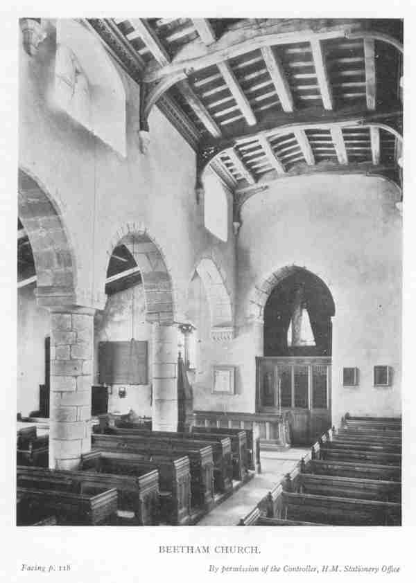
The Church of St. Michael originally belonged to the Abbey of
St. Mary's, York. After the dissolution the rectory continued in the hands of
the Crown until James I granted it to Sir Francis Ducket of Gryrigg. It is now
in the git of the Bishop of Carlisle. The earliest part of the existing church
is the lower part of the tower which is reputed to be Saxon but is described in
the "Historical Monuments Survey" as Norman. A south aisle was added about 1200,
and perhaps in the 13th century the chancel was extended to the east. The
Beetham chapel in the south-east corner of the church is 14th century work. In
the chancel on the south side of the Communion table there is an altar-tomb with
quatre-foiled panelled sides enclosing shields-of-arms of various families
including those of Beetham (argent a chief indented azure), Musgrave,
Harrington, Strickland or Dace (who both have three scallops on their shields)
and Middleton. Upon this altar-tomb are two effigies of a man and a woman in
stone, but it is not quite clear who they are. According to Dr. Burn 'they are
said to be the monuments of the last of the Beethams, Sir Thomas and his wife;
he is in a coat of armour, his sword by his side"; she is wrapped in a shroud;
the "Historical Survey" calls them "a man and wife of the Beetham family"; while
a third authority says they are "Sir Robert Middleton and his wife Ann, daughter
of Roger de Betham." Both effigies are mutilated and headless and perhaps we
shall never be really sure about their identity; nor perhaps does it matter; it
remains, as the "Survey" says, a "noteworthy altar-tomb."
Dallam Tower was built in 1720, on the site of an earlier
house, by Daniel Wilson (1680-1754), who was M.P. for Westmorland for nearly 40
years, and here his descendants have lived ever since. It has the perfect
setting of an English country house, situated in a picked position with the
river in front and a hill behind; surrounded by a park, all ringed round with a
wall; you can see it from the Milnthorpe road; you can walk through the park, as
my wife and I have done, over the hill to Storth. There are features at this
place very like those at Rydal - the undulating park, the beck through it, the high ground and woods behind the house - and I have
sometimes thought that when the Wilsons of Dallan Tower and the Flemings of
Rydal Hall inter-married, as they did more than once in the 18th century,9 each
of them must have feel very much at home in the other's house.
The "historic farmhouse," to which I referred above, is
Beetham Parsonage Farm. "From the name and position of this farm, it is obvious
that it was the vicarage for the beautiful old Church of Beetham."10 It is close
to the church and has an unusually wide gable-end on its east side; at the back
of the house is an old pigeon-house, a square stone structure of late 16th or
early 17th century date.
But it is Beetham Hall which, to my way of thinking, is the
most interesting of all the buildings in the parish - be they towers, houses,
parsonages, farms, cottages, barns or pigeon-houses - for here, in the ruins of
the castle and in the modern agricultural machinery scattered about the
farmyard, is embodied the spirit of the place from the Middle Ages down to the
present day. The manor of Beetham, at the time of the Norman Conquest, was part
of the possessions of Tosti, Earl of Northumberland, who was dispossessed by the
Conqueror, and at the time of the Domesday survey it belonged to Roger of
Poictou, whose successors took the name of the place and called themselves de
Betham. The Beethams were a powerful family and continued to own it for many
generations. In the reign of Henry IV, John Beetham represented the county in
Parliament;' under Henry V a Commission of Array directed Thomas de Betham "to
muster and array all the men at arms"; in the reign of Henry VI, Thomas Beetham
was M.P. for Westmorland.
Tradition goes that the manor of Beetham was forfeited in
consequence of the battle of Bosworth Field, where the House of York received
their final overthrow in 1485, and that thereupon it was granted to the Stanleys.
It seems to have come into the Stanley family about that time, either by
purchase from the former owner or by grant from Henry VII.
Beetham Hall is now part of the Dallam Tower estate. There are
still Beethams in Westmorland and, on the occasion of my visit, I was
accompanied by Mr. Thomas Beetham of Kendal. We approached by the road from
Milnthorpe to Lancaster and turned sharply to the right, up an avenue to the
farmhouse, adjoining the ruins of the old castle, in the courtyard. Having
knocked at the door of the house, I waited wondering how best to explain who I
was and why I had come. Soon I heard footsteps and the door was rather
cautiously opened by an elderly lady who said that she was all alone as ""the
others""- her daughter and son-in-law, I think --had gone to Kendal. I started
on my explanations but, for anyone with my surname, it is not easy to identify
oneself without going into a lot of fuss and details. I find it saves time to go
straight for local place-names and make contact that way. I said that I came
from Burneside; did she know it? No, she didn't. She came from Crosscrake. That
gave me my chance. Did she know my cousin, Jacob Wakefield? At once her face was
all smiles; at once the door was wide open' the mere mention of his name was a
magic introduction; nor did I wonder, for to know and be known by him is - and I
could see that she felt it, as would any and every farmer in South Westmorland -
at once a link and a privilege. She then said that we could look all round the
buildings, and this we proceeded to do.
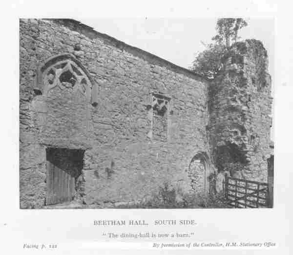
The old hall or castle was built about the middle of the 14th
century with a hall-block in the centre and cross-wings at the east and west
ends; an extensive courtyard was enclosed by a defensive curtain-wall of about
the same age. The existing farmhouse was added on to the old part in 1653 by
Thomas Brabin whose initials appear on the lintel of the former doorway; the
older buildings are either ruined or incorporated in outbuildings. The old east
wing, which was the former buttery wing connected with the dining-hall by
screens, was destroyed in 1644; the dining-hall is now a barn; and the west
wing, formerly the solar wing, with the north-west tower that contained the
chapel, is now in ruins.
There is a good account of Beetham Hall in Nicolson and Burn's
"History"11 :-
"The hall of manor house at Beetham was anciently a large,
handsome building but is now in ruins. It is in a delighful situation, having
the prospect variegated with woods, water and champion12 ground. It hath been
built castlwise, and by Leland and others it is called a castle. Like all the
other old houses in the northern parts it hath been built for defence as well as
ornament. In all of them there was one large room called the hall, where they
transacted all business and, according to the laudable practice of hospitality,
entertained and feasted their friends and dependents; hence came the proverb,
'Tis merry in the hall
When beards wag all.
College halls and halls of trading companies have some remains
of these ancient customs."
It is clear that Dr. Burn approached the building from the
same side as we had, only whereas there is now a wide motor-road at the foot of
the avenue he, in the 18th century, came up from the Bela. I continue to follow
his narrative because, though published so long ago as 1777, it is true of the
place to-day.
"By an easy ascent from the river, we come to a gateway, being
the grand entrance into the castle-yard. Entering there we find ourselves in a
fine, large, open area, 70 yards long by 44 in breadth. On the right appear to
have been some buildings as low as the walls of the yard to the length of 98
feet, like barracks for the soldiers." This, no doubt, was where "the men at
arms" would have their quarters whom Thomas de Betham was directed by Henry V to
"muster and array."
"On the left we have a charming view of the castle, standing
at the south end of the area. The walls of the yard are 3 ½ foot thick with
loopholes for the archers, at proper distances. The windows in the hall are high
up in the wall, and small in proportion to the room with much Gothic-work about
them. Up one pair of stairs (in the south-west tower) there hath been a chapel,
with a separate back staircase to it, whereby the tenants and neighbours might
come to the chapel without disturbing the family."
To the south of the castle there is a steep fall of ground; to
the west was formerly the park.
As I walked away from Beetham, rather sadly because this was
the last item on the programme of our tour, I put the old hall, which I had just
see, in the same class as Wharton and Middleton. All three are active
Westmorland farmhouses on regular, up-to-date lines, but all of them are
surrounded by old mediaeval walls and they still have, among their outbuildings,
the bygone grandeur of dining-halls, screens, buttery wings and solars. All
three differ completely from the "dead" museum-pieces of castles in the care of
the Ministry of Works, such as Brougham and Brough, just as they are totally
unlike the "living," and lived-in, castle of Appleby. The rubble heaps of
Hartley and Lammerside castles are, in a separate class again coming, as time
goes on, nearer and nearer to the appearance of Roman remains. But Beetham,
Wharton and Middleton are still capable of retaining, and even reclaiming in
some of their buildings, part of the beauty and dignity of former days, provided
that a certain amount of money could be spent on their weak spots.
I have already dealt with this problem in the case of Wharton
Hall13 and I will not dwell on it more heavily now, except to say that since I wrote about Wharton, an
article has appeared in the Times14 describing the fate of "those great houses
of Old England which their present owners can no longer maintain." Should these
houses be converted into museums, colleges, guest-houses or show-places? I am
writing more particularly about the houses of Old England which have already
lost much of their glory and are now partly in ruins, but have still enough
roofs to make some restoration possible. The writer of the Times article is
really making the same point that I am trying to make when he says: "These
ancient houses, if they cease to be homes, should pass into the keeping of
guardians who will care disinterestedly for their beauty and historical
association." Wharton, Middleton and Beetham are all to a great extent in ruins,
but they are still "homes" as farmhouses and something should be done to
preserve their present beauty and prevent further decay. They are part of our
National heritage.
When I look at the ruins of these three places I cannot help
thinking that if the Lady Anne Clifford were to return to earth in 1947 she
would at once start rebuilding them, licence or no licence; having restored them
she would then put up an inscription on each of them, recording how long they
had "layen" ruinous, what she had done to repair them, how she had come to lie
in them herself for a little while; and finally she would have presented their
owners with door-locks made for her by George Dent of Appleby, at a cost of £1
each, bearing her initials, A.P.
1 Spelt "Millthrop" on the map in West's "Guide to the Lakes,"
1779, and so pronounced to-day by many Westmorland people.
2 "The Journeys of Celia Fiennes," 1947.
3 "The Coast Line of England and Wales," by JA. Steers.
Cambridge University Press, 1846
4 Nicolson & Burn, Vol. 1, p. 202.
5 In "Sea Breezes," March, 1947.
6 "Historical Monuments Survey," 1936, pp. 14 and 41.
7 A.Heaton Cooper
8 "Pennant's "Tour."
9 Edward Wilson of Dallam Tower married, 1746, Dorothy Fleming
daughter of Sir William Fleming, M.P., of Rydal. In 1739 William Fleiming, son
of Sir George Fleming, married Dorothy Wilson daughter of Daneil Wilson, M.P.,
of Dallam Tower.
10 "Historic Farmhouses," p. 14. Westmorland Gazette Ltd.,
1944
11 Vol. 1, p. 224.
12 Dr. Burn seems to have dropped into his native speech.
"Champion" is in frequent use to-day in Westmorland, meaning good or
first-class. In answer to the question "How are you?" you will ofter hear the
answer "Champion, thanks," or just "Champ," abbreviated as are so many other
words nowadays.
13 See Chap. III, p. 30.
14 11th October, 1947.
Thanks to Diane Coppard in Leicestershire for transcribing this! Reproduced by
permission of Tim Clement-Jones.


