A Tour In Westmorland by Sir Clement Jones, published 1948
CHAPTER VIII
HIGH CUP NICK
HIGH FORCE - CALDRON SNOUT - CROOKBURN BECK
When the weather is mentioned in the headlines of newspapers
instead of being tucked away, as it normally is, in small print at the bottom of
the page, or, in still smaller type, along with lighting-up time at the top, you
may be sure that it has not escaped the notice of hikers and holidaymakers in
their home-going postcards. On 2nd June, when we started our tour, the heat was
very much in the news as well as on the road. "Hottest weather for 92 years" we
read; on the 4th the story was much the same: "Six days running over 85." But
there were some sinister looking clouds while we were at Kirkby Stephen and we
assured each other that we had better make the best of the fine weather. It
wouldn't last. And, for once, we were right; during the next two days there was
a drop of 28 degrees, and by the time we reached Middleton-in-Teesdale on the
6th it was even colder and wetter than when we left Kirkby Stephen.
Our plan in coming to Teesdale was to see the Pennine range and the Westmorland
border from the Durham side; to visit the waterfalls of High Force and Caldron
Snout; and, if possible, to get as far as High Cup Nick and the junction of
Crookburn Beck and the Tees (where meet the counties of Cumberland, Durham and
Westmorland). As we had no car and no bus guide, we were uncertain to what
extent we might be able to carry out this programme. In the end we were able not
only to complete the whole of it but even to add to it, owing to the kindness of friends
in the hotel who gave us a lift in their car. Once again I render thanks to
motorists, and if ever Mr. and Mrs. Harris should read this book I hope they
will realise how grateful my wife and I are to them. I hope they will also bear
witness that we did not throw out hints or fish for a lift, or hang about in the
front hall of the hotel in a hopeful, expectant manner. "Sursum Corda" - Lift up
your hearts - is the motto of my old school, but "Lift up your friends" seems to
be the text followed by the Harrises, for I know now, since I learnt later, that
they make it a rule never to go out for a drive without first offering a lift to
somebody.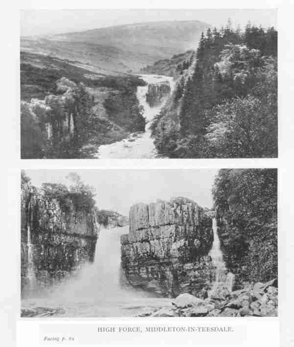
In this way, and with them, we planned overnight a combined operation by car and
on foot to High Cup Nick. It would have to depend on the state of the weather
but we would get to Caldron Snout anyhow.
We woke to find pouring rain and a high wind from the north-west. We stowed our
spare shoes and stockings in the car and set off from Heather Brae Hotel, where
we were staying, along the road to High Force. We had seen the wonders of this
place on the previous afternoon. High Force has been described as "the finest
waterfall in the kingdom" with which I entirely agree, for though I have seen
many forces and falls in different parts of Westmorland and Cumberland and other
counties, I have certainly not seen anywhere else such grandeur of setting or
such a fine fall of water. You approach it from the high road down a path
through a wood of fir trees, and at the end of the path you hear straight ahead
of you the thunder of the fall. The Tees, at this point on its journey to the
sea, having carved itself a deep bed in the basalt, hurls itself over a
square-headed mass of rock with a drop of over 70 feet into the canyon below.
The colour of the water is brown from the peat bogs above the fall; the upper
part of the rock is basalt, with vertical lines of limestone beneath. In a
chapter called "Geology in Westmorland," in Kelly's Directory of the County,
The ground is literally cut from under your feet. There is no foreground to look
at but you see, through the broad open gap at the western end of the horseshoe,
the Valley of the Eden some five miles away to the west, and beyond that in the
far distance the outline of the high fells of Cumberland in the Skiddaw
direction. It was like standing on the rim of an empty cup, looking across the
tea-leaves with a broken gap in the far side of the cup. The rim is in fact
composed of the same igneous rock that we noticed at High Force. "Here," says
the writer on that subject, "the Whin Sill is well seen along the western face
of the Pennine escarpment, one of the finest sections being at High Cup Nick,
where the basalt is 73 feet thick and has baked or altered the shale beds both
above and below it."
It is always a pleasure to visit a district with a geological formation and
flora and fauna different from those to which one is accustomed. This was
certainly true in our case, coming from London, and the Teesdale country, round
Middleton and up to High Cup Nick, had been no exception. In boggy, heathery
moorland on this higher ground one does not look for flora but the bird-watchers
had had a good day with the dunlin nesting and the large number of golden
plover, and now it was the turn for geology. Nothing like the precipitous basalt
edge of High Cup Nick had been seen before by any of us.
[text omission]
[88]
when we explained to him which way we had been to High Cup Nick that by the time
we got back to Cow Green we should have walked 15 miles as near as made no
matter. He seemed to imply, without actually saying it, that this was not a bad
performance for us old 'uns, considering the weather and the rough ground, and
we old 'uns secretly felt rather pleased with ourselves. Mr. Airey thinks
nothing himself of walking the ten miles or so from Birkdale over the moor to
Appleby when he wants to go there to see his relatives, but his sister, being
unable to make so long and arduous a journey, walks a shorter distance, in the
opposite direction, to Langdon Beck where she can get a bus to Barnard Castle;
there she changes into another bus for Kirkby Stephen, and so to Appleby - a
journey of some 40 miles which take her 11 hours! On one very rare and memorable
occasion in the 1945 General Election, she and her brother were offered a lift
by car all the way from Cow Green, round by Middleton and Brough to the polling
booth in Long Marton which is about a mile from Dufton village. It was to be a
long drive and a great event, but alas! it never came off. The Aireys arrived at
the appointed time and place near the Tees where the car was to meet them, but
when they got there the road was bare; there was no car and so their votes were
never registered.
* See p. 21.
Elections are favourite topics of conversation with farmers, quite apart from
the political issues involved or the party programmes. Indeed a far greater
interest is taken in the character of the candidate than in the cause for which
he stands. If the modern candidates of to-day are blameless, worthy men, then
let us go back to some ancient Victorian day when the hustings really were
hustings. "Do you remember old Mr. X?" asks a farmer friend of mine. How could
I, seeing that he was dead before I was born, but I had heard tell of him so I
say "Yes," in the hope that my friend will continue. "He was a great Parliament
man," he went on, "but he had his failings." My friend then looked at me in a
very knowing way and raised his elbow twice, fearing perhaps that I might have
overlooked his first movement.
He pursed his lips outward and drew in a quantity of breath in a disapproving
way and added "Ay, he went bit mark." I missed the point of this and then saw
it. He, the parliamentary candidate had overstepped the mark; he had gone past
the mark; he had gone by the mark. "He went bi' t' mark" my friend repeated.
Then followed a story of how this same candidate on one occasion was to have
addressed a public meeting in a Town Hall; and all the people came; the place
was packed ; they waited and waited; but the candidate never arrived; "and then
word coom that he'd got the tuithache." More knowing winks from my friend.
Of another Conservative M.P. at a later date it was said by Liberal critics that
the man wasn't a suitable member for Westmorland at all, seeing that he seldom
went to the House and never spoke during the whole session. To which came the
famous, oft quoted Tory reply: "Better if he stayed in his hotel aw' t' time
than bin a Liberil." A delightful idea this, that the representatives of the
people who were returned to Westminster were constrained to dwell in hotels! It
might be true of 1947, housing accommodation being what it is, but very unlikely
in the eighteen eighties when practically every M.P., whether a Liberal or a
Conservative, had or took a house in London while Parliament was in session.
That two lonely farms at Birkdale situated in a wild mountainous district,
separated from their polling station by miles of moorland should be included in
Westmorland at all seems to a mere visitor at any rate to be a clear case for an
alteration of the county boundary, because Birkdale is for all practical
purposes in Teesdale. It is to Middleton-in-Teesdale that the farmers come on
Saturdays for groceries and gossip, and though the two farms are in Dufton
parish there is no possibility of their using Dufton for either social or
religious purposes, separated from it as they are by miles of heather, bog,
becks and the high watershed.
To alter the boundary, however, and bring these farms into Durham would, I
realise perfectly, lead to a fierce controversy into which I would not dream of
entering. It so happened that while we were there, a proposal had been made
under a County Boundary Commisson to make some adjustments in another part of
Yorkshire. A local paper had flared up at once. "North Riding will fight" was
the heading, and underneath I read "full resources will be used against any
unreasonable attempts to annex any part of the Riding." There was the spirit of
the Lady Anne Clifford alive again!
CROOKBURN BECK
Westmorland is, to a small extent, a coastal county bounded by the sea at the
head of Morecambe Bay and by four continguous counties, namely, Lancashire,
Cumberland, Durham and Yorkshire. It therefore follows that there are four
three-shire meting places. There are firstly the three shire stone at Wrynose
above Little Langdale (probably the best known and the most frequently visited
of the four); secondly, the county stone on Crag Hill near Kirkby Lonsdale;
thirdly, the junction of the Tees and Maize Beck at Caldron Snout; and fourthly
the junction of the Tees and Crookburn Beck in the extreme north-east corner of
Westmorland.
It is the last of these with which I now deal, and I suggest that it might be
called the Crookburn meeting to distinguish it from the others. As our
headquarters were then at Middleton-in-Teesdale we approached it from the Durham
side, but you could get to it just as well if not better from Alston in
Cumberland. The distance from Middleton to Alston by the main road is about 22
miles; 14 from Middlton to the top of the pass and thence a run of eight miles
downhill into Alston. It is at the top of the pass that the road crosses over
the little (as it then is) Crookburn Beck, and it is there that you have to
leave the car and start walking. If you (or your friends who may be kind enough
to lift you) can spare the time and the petrol for the longer journey, it is
well worth while to drive the whole way to Alston and back, because by going
over the pass and returning up the hill you get a better picture of how
Westmorland and
Cumberland meet at this point and how Crossfell on the northern side dominates
their meeting. We were fortunate in being taken the long way.
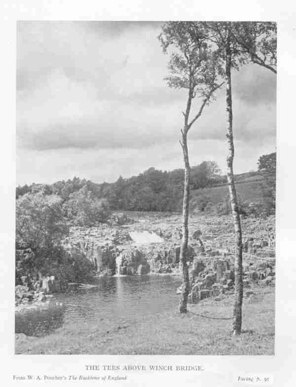
But first we were to see a very lovely bit of the Tees a few miles to the north
of Middleton and to the south of High Force. We left the car and walked across a
field to Scorberry Bridge; here we crossed over the Tees to the Yorkshire side
where we noticed a wealth of wild flowers; one field, in particular, covered
with pale orchis, another with wild pansies of varying colours and sizes -
purple, yellow, blue and yellow half and half, and pure white. We then walked
upstream to Winch Bridge where we recrossed the river to the Durham side and so
back by a footpath to Bow Lees and the car.
As we had already seen High Force and Caldron Snout and Langdon Beck, we passed
these by, and went steadily forward up the main road to Alston with the Harwood
Beck below us on our left. We had also passed by a number of quarries from which
great quantities of road material are being taken, after being put through high
and hideous mincing machines. Formerly, and until recently the London Lead Co.
owned and operated lead mines here. The Company was formed in 1692 under a
charter of William and Mary, and finally closed in 1905 after 200 years of
activity. The principal lead mines were in this part of Teesdale, but owing to
the low price of the metal and the decreasing percentage of silver found in it
the Company came to an end.
An industry that still survives in this neighbourhood is that connected with
barytes or sulphate of barium. This is a heavy, white mineral occurring in
veins, carrying lead and zinc ores. It is used in the preparation of white
paints for wallpapers and for bleaching flannel. Westmorland has been an active
producer of barytes at Brough and at Dufton Fell, and there is a mine that we
saw working at Cow Green close to the Tees above Caldron Snout.
It is a long pull up the Alston road to the top of the pass. Here at Crookburn
Bridge (see ordnance map) you take an old, disused road called Yad Moss Lane,
which after about a mile or more becomes a sort of grass terrace walk with a
magnificent view across to the west. Below is the junction of Crookburn Beck and
the Tees, where the three counties (Durham, Westmorland and Cumberland) meet;
beyond is the towering height of Crossfell in Cumberland, just over the
boundary. It is one of those places which in the days of my childhood used to be
called "scream points." They were given this name because, when you came to
them, you couldn't help calling-out "Oh!" The earliest "scream point" that I can
remember was on the road from Kendal to Staveley, where, as you come round a
corner, you suddenly see the whole range of the high fells of the Lake District
spread out in front of you. No visitor can go there on a fine day without
exclaiming vociferously: "Oh, how lovely!" ; in short, he "screams" when he
reaches that "point." If he doesn't there must be something amiss with him. This
spot on which we now stood near Crookburn Beck is a real "scream point."
From this grass terrace you can either follow the old Yad Moss Lane, which
becomes Peghorn Lane, downhill to Langdon Beck Hotel, or, if you have left your
car or bicycle at the top of the pass you can return, as we did, to Crookburn
Bridge on the main road. I am well aware that the traveller who comes back from
a far country with stories about places which he has seen that others have never
seen is liable to become, if not discredited at any rate regarded as a noted
bore, with no one to check the truth or stop the flow of his yarsn, but I have
met so few people in Westmorland who have ever seen the junction of the
Crookburn Beck and the river Tees that I merely recommend those who are fond of
scenery to go there at the earliest possible occasion, and I leave it at that.
1 * Kelly's "Directory of Westmorland," 1938. p.13.
2 "The Handbook of British Birds," H.F. Witherby, 1940.
3 W.A. Poucher, "The Backbone of England." Country Life, p.
194.
Thanks to Diane Coppard in Leicestershire for transcribing this! Reproduced by
permission of Tim Clement-Jones.


