Page last updated
12/06/19
Redford Grove
'Weardale in pre-historic times supported food gathering and hunting peoples
and later farming families supplementing their living with the chase from late
Mesolithic times to, at any rate, the end of the Bronze age'. Flints have been
found further up the Euden Beck above the Grove towards Redgate Shield.
Redford Grove was originally known as Eudenleys and is first mentioned in
Bishop Hatfield's survey of the See of Durham in 1380AD. Part of the 'township'
of South Bedburn in the Manor of Wolsingham, it consisted of one building and
ten acres of land rented by the Dean of Auckland for 2s 6d per year. The suffix
'ley' implies a clearing from the waste or forest which covered the area at the
time of the Norman Conquest. (The Euden Beck might have been named after the Eure
family who held Witton Castle and much of the land in South Bedburn or possibly
derived from Iwdene 'Yew Tree Valley' ). It was
probably occupied throughout the year unlike the clearings at Ayrehope Shield
and Redgate Shield for which the term 'Shield' (shieling) implies they were used
for summer grazing. It is likely to have been cleared in the middle of the 13th
century - better quality land on the Wear between Wolsingham and Witton was not
cleared until that time but on the other hand 'Rootford' (Redford) just
downstream on the Bedburn had been cleared by 1256. (Hamsterley Church was
founded around 1180).
The 'manor' known as Rutynford in 1369 had been acquired by Sir John de Eure
in the c1350s and formed part of the dower of his wife Margaret. At her death in
1378 it was known as Retynford (held of the heirs of Stephen de Birden).
Four centuries after Bishop Hatfield, prior to the passing of the Hamsterley
Inclosure Act in 1760, Euden Lees (or Euden Leazes) had probably changed little.
By 1760 Euden Lees was owned by Farrer Wren and Myles Sandys but the cleared land had
been extended by an additional inclosure to the north of Euden Beck called 'Crow
Nest' belonging to John Blackett and by other land south of Euden Beck and to
the west of Euden Lees belonging to John Addison. In the discussions deciding
the allotment of land under the Inclosure Act Wren and Farrer claimed unique
usage of the land on the south west side of Pennington Rake and were confirmed
in that land under the enclosure. George Surtees of Mainsforth had been building
up holdings of land in Hamsterley (?), Lynesack and Softley which entitled him
to a major allotment of land when the moors were enclosed as a result of the
act. He took for this allotment the moorland forming the most of the watershed
of the Euden Beck and the hillside to the south of the Bedburn Beck. He then
aquired Euden Leazes from Wren and Sandys and Redford with its allotments from
Patrick Lyon to complete an estate which effectively forms Hamsterley Forest
today. Over the next century the Surtees continued to build up the estate by
purchasing farms in the area such as Podge Hole and Mayland. Their main seats
however were at Mainsforth and Redworth.
|
Crosier Surtees succeeded to the Surtees estates in 1769 by direct succession
and by marrying his cousin the co-heir but fell out severely with his wife (or
vice-versa) and retired to live at Pennnington Rake around 1800 with a woman who
bore him several children. He died in December 1803 having been found frozen
after falling from his pony returning from a dinner at Raby Castle. He was
succeeded by his son Robert Surtees who continued to live at Redworth House.
Around this time the Surtees appear to have changed the name of the property
from Eudon Leazes to The Grove although the house was still on the original site
some 250m to the south west of the current building. The first part of the current building was erected sometime between 1820 and
1851 as a hunting lodge for the Surtees. It was advertised in the Durham County
Advertiser in 1831. It was extended with what is now the
middle section around 1893 and a further extension was added to the northeast
around 1912. The bridge across the Spurlswood Beck is dated 1843 (rebuilt 2003).
|
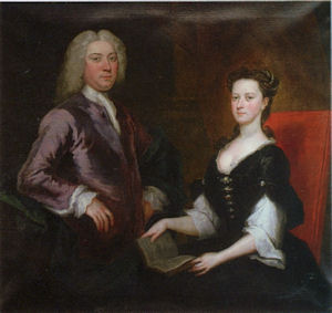
Crozier and Jane Surtees (by unknown artist) |
|
Robert Surtees was succeeded by his son Robert Lambton Surtees in 1857 but
he died in 1863 to be succeeded by his brother
Henry Edward Surtees. Henry developed
The Grove as a hunting lodge and kept a pack of hounds at The Grove until the
1870s. Henry Edward was in turn succeeded by Henry Siward Surtees in 1895 who
built the extensions to the Grove.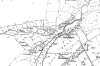
(Map of Redford Grove and surrounding
area 1859)
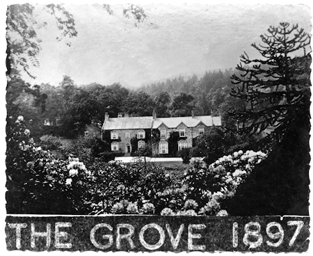
Handwritten on the back is 'Built 1893'
More information on the Surtees can be found in
"Records of the Family of Surtees" privately printed by H Conyers Surtees,
viewable at Durham County Library
|
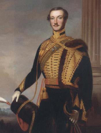
Henry Edward Surtees 1843 |
The next big change came in 1927 when Henry Surtees sold the Redford Estate
to the Forestry Commission for £15,000. George Paton
Pollitt, a director (1919 - 1945) of Brunner, Mond and Company which formed part of ICI
when it was formed in 1926, had rented The Grove but moved out after the sale. Most of the hillsides were already plantations as
early as 1860 but the Forestry Commission developed the whole estate as
woodland. See
'Finding hope in happy Hamsterley'.
Around 1946 Lewin, a refugee from Germany in 1939 and owner of a clothing
factory in West Auckland, rented Redford Grove from Forestry Commission for nominal rent (4/6d?)
on condition that he repaired the house. The main property was split into three
sections plus the asociated cottage. On conclusion of the lease in 1982
his descendants bought the property and it has been in private hands since that
date.
"Walks in Weardale" by W. Herbert Smith second edition 1885 includes (p133)
'A Paper on the Bedburn' by J.P. Soutter with the following section relating to
The Grove:-
'If not the largest the Bedburn is one of the most picturesque tributaries of
the Wear. Rising on the heather-clad moors betwixt Wolsingham and Eggleston,
which fom the watershed of the Tees and Wear basins, it pursues an almost
uniformly E.N.E course and nearly parallel with the main valley of the Wear till
it merges its waters with the larger river a mile above the village of Witton-le-Wear.
Geologically, the whole basin of the Bedburn may be said to be formed of the
Millstone Grit series of rocks, so that if its banks may not display the
luxuriant verdure of a limestone burn, or the rugged grandeur of a basaltic
gorge, still its course is never tame or its scenery insipid. Its current is
always sufficiently swift and strong from the rapidity of its descent to prevent
any stagnant reaches, and its crystal waters retain their pristine purity
unsullied by any manufacturing contaminations. For although there are several
charming residences on the estates through which it flows, yet there is neither
church, chapel, school, nor publichouse in its drainage district. After the
first few miles of its course as an incipient rivulet welling out from the
heathery moor, throughout its entire length the banks of the Bedburn are richly
fringed with natural woods or artificial plantations.'
'At the extreme limit of cultivation on the verge of the moorland, standing
on the delta formed by the union of the two main forks of the Bedburn, is
situated the delightful rural retreat of "The Grove", the shooting residence of
H.E. Surtees, Esq., snugly ensconced in the bottom of a deep valley surrounded
on all sides by steep acclivities, and embowered in woods, so that it is
invisible on every side. In summer or autumn, when the fragrant heather is in
bloom and the woods gay with the innumerable rowan trees laden with their bright
coral berries, a wearied harassed citizen could scarcely find a more congenial
retreat to recruit his exhausted energies "the world begetting, by the world
forgot." The only drawback being the insatiable myriads of midges whose
blood-sucking powers and propensities are intolerable. The house itself is plain
and unpretentious, having been modernised and added to at various times. For
miles above and below "The Grove" the steep, sunny, sandy slopes are covered
with thriving plantations of larch in various stages of growth, all giving token
of vigorous health. In early spring, when the slender cord-like branches are
putting forth their light green feathery tassels of of leaves, gemmed with the
young rosy-pink cones, swaying and dancing in the rude breezes of March, then a
larch wood is worth a journey to see. But "The Grove" is so remote that it must
be rarely seen by the ordinary run of visitors to this unfrequented valley.'
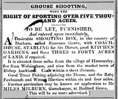
Durham County Advertiser 17 June 1831
"Grouse shooting with the right of
sporting over five thousand acres.
To be let, furnished, And entered upon
immediately
A desirable SHOOTING BOX, in the county of Durham, called Redford
Grove, with COACH-HOUSE, STABLING for Six Horses, good KITCHEN GARDENS, and from
THREE to FORTY ACRES of LAND, if required.
It is situated three miles from
the village of Hamsterley, five from Wolsingham, and nine from the market town
of Bishop Auckland. Coals within a short distance.
Good Trout Fishing
adjoining the House, and the Raby Foxhounds and Witton Harriers within six and
four miles.
Further details may be known on application to Mr MILES MILBURN,
Gamekeeper, at REdford Grove.
This will be no more advertised.