Page last updated 29/01/04
A Tour In Westmorland by Sir Clement Jones, published 1948
CHAPTER V
THE BOTTOM OF WESTMORLAND
WARCOP - DUFTON - MILBURN - NEWBIGGIN
TEMPLE SOWERBY - BROUGHAM
Our plan was to spend the next three days seeing as much as we
could of certain villages in the Bottom of Westmorland of which we had
previously made a list. Westmorland was established as an administrative county
by Henry I in 1131. It was divided into two baronies - the barony of Kendal and
the barony of Appleby or Westmorland. In the "Beauties of England," a guide
book, to which I have referred already, published in 1757, the author writes:
"The Barony or Bottom (from the low situation) of Westmorland, which is the
northern part, affords good store of corn." It was this district that we now
proposed to explore. In a tour of this sort you cannot hope to see every village
on one visit and we purposely left a number of places - such as Kirkby Thore -
for another time. This method of progress, by omission and return, was pursued
by Thomas Pennant on his "Tours," and it is, I think, a wise one especially for
people with limited holidays. On your next journey north you stop at places that
you passed by on the previous occasion. For the first of our three days we had
chosen Warcop, Dufton, Milburn, Newbiggin, Temple Sowerby and Brougham. All
these parishes touch the boundary of Westmorland.
WARCOP
There has been a good deal of argument and misapprehension
about the meaning of the word Warcop. There have been two schools of thought.
Some have held that since the arms of the Warcop family are "Sable three cups
argent," therefore the place must have got something to do with cups. Other
people, including Dr. Burn, have held that the word was never written Warcup,
but Warthecop; and that cop signifies the top of a hill as is found in other
Westmorland place-names, for example Horncop. Whether the first part of the word
is from wath, or ford (over the Eden before there was a bridge), or whether from
ward being kept there has never been precisely decided.
The family of Warcop were living here in the reign of King
John, and continued as lords of the manor until the time of Queen Elizabeth. In
1589 John Warcop sold the property to Thomas Braithwaite of Ambleside and
Burneside, from one of whose descendants it was purchased by Thomas Carleton of
Appleby; it then passed by marriage through the families of Stephenson and
Preston.
The fertile part of the parish lies in the vale of Eden. All
the rest is a wild, mountainous region, remarkable only for its sterility.
Without wishing to enter into the much debated question as to what places the
War Office ought or ought not to requisition for long-range firing practice, it
seems to an outsider that this relatively remote and wild bit of country above
Warcop is as suitable for the purpose as other places that have been suggested,
though we could not help sympathising with the local view which we heard
expressed, that the invasion of the village by the army and the incessant
banging away on the fell above was apt to become trying for the inhabitants.
Warcop Church is an old building much restored with a 13th
century chancel arch rebuilt in 1855. After seeing it we drove on to
DUFTON
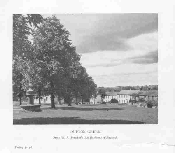
This is a delightful village, well situated among the hills
and a better centre for walking it would be hard to find. It is on the way from
the high fells of the Lake District to the counties of Durham and York. It is
within easy walking distance of Cross Fell, Dufton Pike, Murton Pike and perhaps
best of all, High Cup Nick - one of the grandest sights in the Pennine. Dufton
is said to have been called after some owner in Saxon times whose name was Duff,
"anciently a name in Scotland," says Dr. Burn, "and perhaps also in England."
Its chief charm are the village green, the old hall, and on a hot day, as it was
when we were there, the shade of the trees. On the green stands a fountain built
some 90 years ago by a Mr. Wallace of the London Lead Company, which formerly
worked the lead mines in this neighbourhood.
Those who like to find a village church beside the village
green, in the centre of the village, preferably old and certainly beautiful,
will be disappointed here, for Dufton Church fails in all these respects; it is
about a mile from the village; it is neither old nor beautiful; nor is it even
safe to enter it. At our own peril (according to a notice outside) we did
approach it and peer through the glass of one of the windows darkly, but could
see little except cobwebs. Dufton Hall, which stands inside the village is an
ancient and interesting building, in the form of the letter L, on the north-east
side of the village green, partly Georgian, rebuilt in 1779, partly earlier
dating from the 17th century. The parish of Dufton occupies a vast tract in the
north-east corner of Westmorland, stretching from the Durham border westward for
a distance of about eight miles, and from north to south about five miles. It is
bounded on the north by Milburn Forest; on the east by the river Tees; to the south is Appleby about three miles away.
I cannot
think of any parish in Westmorland which combines such contrasts of scenery as
exists between the two sides of the Pennine watershed. On its east side, near
the Tees, it contains some of the wildest country still left in England -
mountains and moorland swept by winds from Cross Fell; to the west, on the other
hand, all is quiet and fertile; it is almost the difference between a tiger in
the jungle and a cat
in front of the fire. I shall have more to say about the tiger side of the
parish when I come to explore that part of it from Teesdale. For the moment it
is time to go on to
MILBURN
Probably called after a watermill on the beck here, Milburn is
the most northerly village in the county and very charming it is. It has several
features comparable to those which we noticed at Dufton, namely, the wide
village green, the church at some distance from the centre of the village; the
historic farmhouse - Howgill Castle, formerly the seat of the lords of the
manor; and Milburn also has the hem of the skirts of the Pennines at her feet,
with a fine prospect to the south-west.
Possession of the manor has passed through several families.
King John granted Milburn Forest to William de Stuteville; later it was held by
Vipont, Lancaster, Crackenthorpes and Sandfords and now it belongs to Veteripont
Estates Ltd. The parish church of St. Cuthbert, formerly a chapel of Kirkby
Thore, is a quarter of a mile or more from the village, but unlike Dufton Church
it is an old building with bits of 12th century work to be seen; the re-set
south doorway is Norman and re-used stones are of the same date.
We found a place for lunch in the shade of a tree near the
little beck below the church and afterwards drove on to
NEWBIGGIN
There seems to be no controversy about the meaning of the name
of this place. It is simply new building, "big" being a word signifying to
build. Newbiggin is a small parish separated from Cumberland by the Crowdundale
beck, which comes down from Cross Fell. This river, which is the boundary
between the two counties, until it falls into the Eden, is called Blencarne Beck
in the old map in Nicolson and Burn's "History," but in all the modern maps that
I have seen, it is Crowdundale. The manor house stands at the north end of the
village and was built by Christopher Crackenthorpe in the reign of Henry VIII.
That family have lived here since the time of Edward III, when Emma de Newbiggin
married Robert de Crackenthorpe, who is supposed to have been a younger son of
the Machells of Crackenthorpe near Appleby.
Leaving Newbiggin we went on to
TEMPLE SOWERBY,
where we had intended to call at the manor house, but when we
got there we found what I daresay most people who take picnic meals out-of-doors
have sometimes experienced, namely, that in packing-up after lunch a bag was
left behind. This meant that the car must return to Milburn for the missing bag.
Nothing could have been more fortunate because it gave the two of us who
remained an opportunity of seeing more of this lovely house and garden than we
should otherwise have done. The very name of the place is interesting. Temple
Sowerby is so-called, by way of distinction, from its having belonged to the
knights Templars, for there are two Sowerbys in the Bottom of Westmorland, the
other being Brough Sowerby.
The Knights Templars, a military religious order, were first
established in 1119 for the protection of the Holy Sepulchre. Pennant writes
about the Templars: "Their great wealth and power rendered them insolent and
formidable. Under pretence of crimes of the most horrid nature, their persons
were seized, their riches confiscated and their order totally suppressed in
1312." Eleven years later their possessions, including this manor, were by Act
of Parliament given to the Knights Hospitallers. In the interval Temple Sowerby
was held by Robert, Lord Clifford, by way of escheat. The manor was held by the
Hospitallers until the dissolution of the religious houses by Henry VIII, who
granted it to Thomas Dalston, eleventh in decent from the first of that name of
Dalston in Cumberland. It remained in the Dalston family until the 18th century.
The name of the house is recorded as Acorn Bank in 1615, when
"Sir Christopher Dalston of Acorn Bank was knighted by King James I," and by
that name the old manor house was known until a few years ago when it was
changed by the present owner to Temple Sowerby Manor. Formerly it was called
Acorn Bank because the land in front of the house and all round it was at that
time covered with oak trees, but to-day there is a belt of trees only on the
north side of the house, which stands on the brink of the Crowdundale Beck. From
the terrace on the south side of the house there is a magnificent open view. We
were unlucky when we called in finding that the owner, Mrs. McGrigor Phillips
(Dorothy Una Ratcliffe, the authoress), was away from home, but her staff very
kindly showed us round and we came away thinking what a beautiful place it is
and how grateful the public must be to Mrs. Philips for her generosity to the
National Trust.
The car (and the missing bag) now arrived and we all went on
to
BROUGHAM CASTLE
On the way there and about half a mile from the castle, on the
Penrith-Appleby road, we saw and stopped at the Countess's Pillar, to which I
have referred in the chapter on Anne Clifford.
Brougham Castle has had a history very similar to that of
Brough. So much so that the comparison between these two places, whose very
names are so much alike, are worth writing down. Each of them was built on the
site of a Roman camp; each was part of the great property that passed in the
reign of King John to the de Veteripont (or Vipont) family and later by marriage
from the Viponts to the Clifford; each keep was built in the 12th century; both
were attacked and destroyed by the Scots; both were restored by Lady Anne
Clifford between 1650-60; both were demolished by her grandson, Thomas Tufton,
6th Earl of Thanet, about 1690; the ruins of both castles are now under the
guardianship of the Ministry of Works.
And very much the same may be said of Appleby Castle - the
part about the Romans, the Viponts, the Scots and Lady Anne Clifford; there is,
however, this important difference that Appleby Castle was not demolished by
Lord Thanet in the sixteen nineties, but was rather improved and enlarged at the
expense of Brougham and Brough and therefore to-day it is lived in by Lord
Hothfield and not looked after by the Ministry of Works.
As you enter the main road and buy your ticket from a man at
the lodge, you will be struck by the size of Brougham Castle and the beauty of
its setting on the south bank of the river Eamont. You will probably agree with
the Monuments Commission that "the remains of Brougham Castle form the most
extensive and important survival of military architecture in the county. The
12th century keep is still largely complete, as are the two gatehouses, the
three together forming a remarkable example of defensive planning."1
It is a much bigger and grander affair than Brough; it is far finer than Kendal
Castle or Pendragon could ever have been; it is in fact a magnificent structure
and one of the strongest of all the Border fortresses.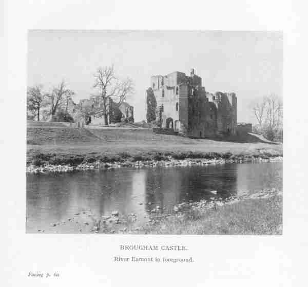
From the lodge you walk up the drive, alongside the river to
the outer gatehouse. This is a great rectangular building, 90 by about 40 feet,
with an arched doorway; over the arch is a sunk panel, removed to this place
from the inner gateway, and bearing the inscription "Thys made Roger." The
wording has always been regarded as ambiguous. Roger de Clifford, who had
married the Vipont heiress, is supposed to have erected the gatehouse. Like all
sons-in-law he was looked upon as an intruder in getting so good a property and
there were those who were only too ready to say: "This made Roger; yes, it
certainly did; he would be nothing without his wife's castle." But there were
others, perhaps with kinder hearts, who admitted the fact: "Roger made this; he
put up this building." Be that as it may, the authorities on the subject say
that the panel
replaces another one now at Appleby Castle. It contains one of those
inscriptions of which Anne Clifford was so fond, of which she composed and left
so many. The inscription reads:-
"Brougham Castle was repaired by the Lady Anne Clifford,
Countess Dowager of Pembroke, Dorsett and Montgomery, Baroness Clifford,
Westmorland and Vesie, Lady of the Honour of Skipton in Craven and High
Sheriffesse by inheritance of the countie of Westmorland, in the yeares 1651 and
1652, when King James lay in it for a time in his journey out of Scotland and
towards London, until this time. Isaiah, Chap. 58 verse 12. God's name be
praised."
While the whole castle is in ruins there is enough left of
each part of it - and a great deal of some parts, especially of the keep and the
two massive gatehouses on the north side next to the river - to give one a very
good idea of how the castle looked and "worked" in its great days. Nothing is
missing of the essential bits and pieces that go to show the general layout; the
approach; the entrance through the gate-houses; the courtyard beyond; the keep
with its 13th century chapel or oratory covered with a ribbed vault and central
boss; the curtain walls; the kitchen and great hall; the lodgings and the
south-west tower in the corner of the courtyard furthest from the gatehouse.
We sat in the courtyard for a while to enjoy the beauty of
this massive stronghold and of the river Eamont below us. We could not, however,
wait long as we still had two more items on the day's programme before returning
to Kirkby Stephen; the first was to get tea in Penrith just across the river,
and the second to come back to Brougham in order to see the parish church of St.
Ninian, locally called Nine Kirks. As Penrith is outside our self-made province
and as anybody can find the way and tea there, we can omit mention of it and go
straight to Nine Kirks.
Everyone who visits Brougham should make a point of going to
see St. Ninian's Church even though it takes a little time and trouble, as you
cannot drive up to the door. The church stands in a lovely dale within a curve
of the river Eamont; to get to it you leave the main Penrith road at a gate
where there is a notice about the way to the church; you walk over the fields
along a grass track until you come to the river and there you look down, from
the high cliff above to a hairpin bend of the Eamont below you; you carry on and
then drop downhill to a field beside the river, where you find this very unusual
parish church.
There are many other churches beside rivers; many other
churches in the fields; but there can be few so completely tucked away out of
the hurly-burly and bustle of village life or high roads. Here is peace, perfect
peace.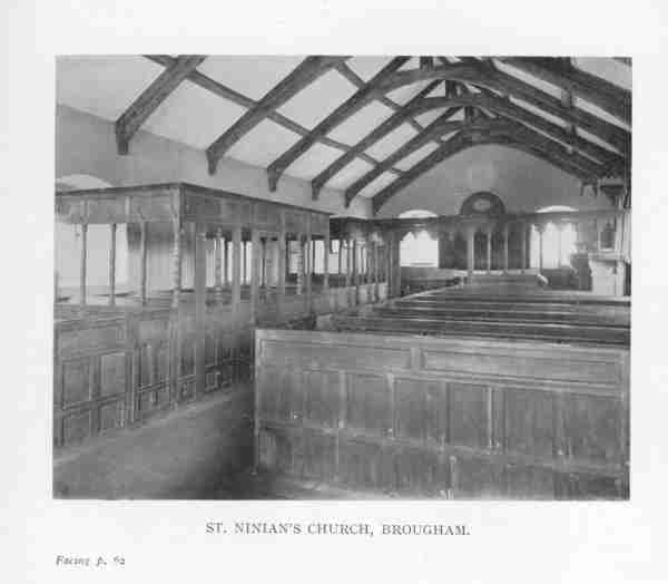
From
the diary of the Lady Anne Clifford it is clear that she pulled down and
entirely rebuilt and enlarged the church in 1660. And, as always, she left her
mark on the fabric of whatever she restored; in this case in the inside of the
church on the eastern wall there is a wreath in plaster enclosing the initials
and date, A.P., 1660 (for Anne, Countess of Pembroke).
On our walk back to the road we stopped to look down at the
bend of the Eamont and watch some oyster-catchers on the riverbank.
1 "Historical Monuments Survey," p. 59.
Thanks to Diane Coppard in Leicestershire for transcribing this! Reproduced by
permission of Tim Clement-Jones.


